


laghi di Colbricon 2018 5 Juillet

ARPF
User
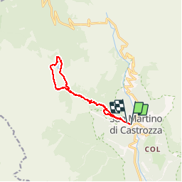

Length
10.7 km

Max alt
1943 m

Uphill gradient
528 m
Km-Effort
17.7 km

Min alt
1467 m

Downhill gradient
521 m
Boucle
Yes
Creation date :
2019-01-15 12:40:12.344
Updated on :
2019-01-15 12:40:12.344
4h38
Difficulty : Medium

FREE GPS app for hiking
 SityTrail
IGN / Geographical institutes
SityTrail Plus
The world is yours!
About
Trail Walking of 10.7 km to be discovered at Trentino-Alto Adige/Südtirol, Provincia di Trento, Primiero San Martino di Castrozza. This trail is proposed by ARPF.
Positioning
Country:
Italy
Region :
Trentino-Alto Adige/Südtirol
Department/Province :
Provincia di Trento
Municipality :
Primiero San Martino di Castrozza
Location:
Unknown
Start:(Dec)
Start:(UTM)
715800 ; 5126991 (32T) N.
Comments